A few showers remain possible before a pattern change brings pleasant weekend weather

The upper-level system responsible for recent active weather will move south and southwest, exiting the area later tonight into early tomorrow morning.
A few spotty showers may linger near or south of the region early Friday, but measurable precipitation is expected to end quickly.
Most of Friday will be dry, particularly from midday to early afternoon, with decreasing clouds and some afternoon sunshine.
Friday morning temperatures will start in the mid-50s and finish in the mid-70s.
Pleasant Weekend Ahead
The weekend will bring pleasant and dry conditions to Oklahoma as a surface ridge settles into the area. Morning lows will be in the upper 40s and lower 50s, with daytime highs in the mid-70s.
Wind will be relatively light and from the northeast due to the location of the ridge of high pressure. Sunny conditions are expected.
The outlook for Mother’s Day is sunny and pleasant.
Warming Trend Early Next Week
Early next week, the upper-level system responsible for previous active weather will shift closer to the Arkansas region.
This may bring a slight chance of isolated showers near the Oklahoma-Arkansas state line on Monday, though probabilities remain low.
Temperatures will be warmer next week. Morning lows on Monday will be in the mid-50s, with daytime highs in the upper 70s.
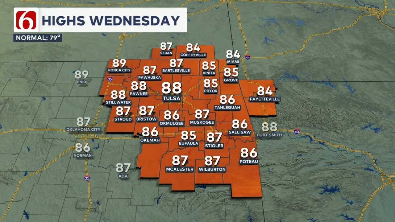
Despite the presence of the upper-level low to the east, mostly sunny conditions are anticipated. A notable warming trend is likely on Tuesday and Wednesday. Tuesday morning lows will be near 60, with daytime highs in the mid-80s.
Wednesday will feature morning lows in the mid to upper 60s, with highs reaching the upper 80s.  Gusty south winds are likely to return Tuesday and Wednesday. The increasing low-level moisture combined with recent rainfall will bring slightly muggy weather into the area.
Storm System Returns Late Next Week
By late next week into the weekend, the pattern is expected to change, bringing a strong storm system near the central and southern Plains.
Based on this setup, thunderstorm chances are expected to return, including the potential for some strong to severe storms.
The Morning Weather Podcast:
The daily morning weather podcast briefing will remain on hold indefinitely due to ongoing internal workflow issues.
We're working to resolve these challenges as soon as possible and appreciate your patience. We apologize for the inconvenience and hope to be back soon. Thank you for your understanding.
-----
Need-to-know severe Oklahoma weather prep:
🔗Severe weather safety: what you need to know to prepare
🔗Tornado Watch vs. Tornado Warning: what they mean and what to do
🔗Severe weather safety: what to do before, during, and after a storm
🔗Why registering your storm shelter in Oklahoma could save your life
🔗Floodwater kills more Oklahomans than tornadoes in the last decade, here's why
🔗'Turn around, don't drown': Flood safety tips for Oklahomans
🔗5 things to know: How Oklahomans can get federal money to install storm shelters
🔗Breaking down the SoonerSafe Rebate Program: Do I qualify for a storm shelter?
Watch us on YouTube!
Follow NewsOn6 on X/Twitter for automated severe weather alert posts >>>>>> @NewsOn6

Emergency Info: Outages Across Oklahoma:
Northeast Oklahoma has various power companies and electric cooperatives, many of which have overlapping areas of coverage. Below is a link to various outage maps.
- PSO Outage Map
- OG&E Outage Map
- VVEC Outage Map
- Indian Electric Cooperative (IEC) Outage Map
- Oklahoma Association of Electric Cooperatives Outage Map — (Note: Several Smaller Co-ops Included)
Follow the News On 6 Meteorologists on Facebook!